I read somewhere that it takes a measure of misery to make a memory. This 75 mile round trip hike from Harts pass to Canada was full of memories, even before I made it to the parking lot. The wrong parking lot.
Drive to the city of Mazama, WA and head N/W out of town on Lost River Rd about 14 miles or so. Lost River Rd is a casual, easy drive the first few miles, but then it radically changes personalities. The single lane road is steep and afflicted with miles of little, annoying washboards at every turn and rise. Then the fun begins. The casual, one-hand-on-the-wheel driving quickly changes to both hands gripping the wheel tightly. The road winds up and up along the edge of a mountain with very few places to turn out if someone approaches from the opposite direction. It's important to concentrate on the road and not gaze down the mountain or the adjacent valleys, which are absolutely beautiful. I had a driving instructor tell me that if you look at something to either side of you car while driving, you will generally drift that way. Not a good idea on this road...eyes forward. Near the middle of the route to Harts Pass, there is a sign (one of only a few) that cautions the driver to travel at 10 mph for 1/2 mile. The reason quickly becomes apparent as the road narrows even more, steepens, and has fallen rocks in the way. The most dangerous part of the road is short and passes quickly. It's also a great place to take a picture of the road (but stop first). After about 45 minutes of driving, is Harts Pass.
The first sign upon arriving, is situated on the left side of the road and it indicates that the Pacific Crest Trail is 2 miles to the left. The sign also has "Meadows" campground listed in 1 mile. Don't take this exit/turn if you are planning a NOBO (northbound) PCT hike. This trailhead is for the SOBO trailhead. Instead, continue about 1 mile, driving past the Harts Pass guard station, and you'll soon arrive a the NOBO PCT trailhead. The NOBO trailhead has a pit toilet, the SOBO doesn't. I made the mistake of driving to the SOBO trailhead.
Although it's an easy, beautiful hike between the trailheads, it was unnecessary.
I began hiking late afternoon. The sun was out, and the temperature was a perfect 72 degrees. I was able to hike on a dry trail for the most part with only one small obstacle. Around 5 miles north of Harts Pass is a creek that was partially snow covered. Crossing required me to step on slippery rocks and up onto the snow. My concern was that the partial snow bridge would collapse, but it held and I was able to continue unscathed. After hiking for about 5 hours, I arrived at the base of Tamarack mountain, and decided to camp there for the evening. I set up my tent and retired early. During the early morning hours, I decided to water the plants and found the sky full of stars. It's amazing the depth of solar systems and stars that can be seen in the wilderness sky. The next morning I packed up my gear and headed north towards Canada.
Rain clouds soon joined the hiking party, and decided to stay for the rest of the week. The temperature also dropped considerably, and would hover between a high of around 58 to a low below freezing...near the end of July!
During day 2 of the hike, I met with two SOBO hikers near Holman pass, and asked them about the detour around a slide that occurred on the north side of Powder mountain. At the Harts Pass reader board a detour was suggested to avoid the slide, but the detour added about 20 miles to the hike. The SOBO hikers stated that the slides were not that big of a deal, and that if I just "kept with it" I would make it to Woody Pass. "No problem" I said under my breath and continued NOBO.
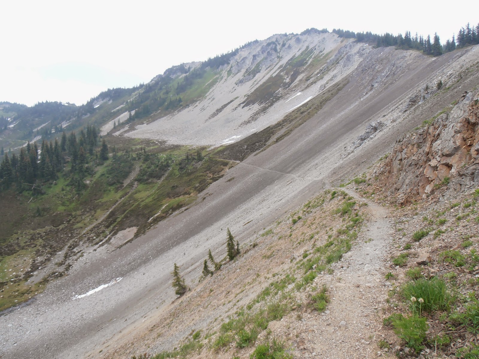
The "slide" area is located along a very loose and gravelly area on the north side of Powder mountain. I found it intimidating at first and wondered how I would ever cross them. The "slides" are not just small areas of loose gravel, but rather ravines that measure 20-30 feet across and just as deep. The sides of the ravines (there are about 5 large slides) are extremely loose and steep. One step into the gravel/rocks initiates your very own little slide. Here are some tips to get out alive and not spend Christmas holiday in the bottom of the slide ravine. First, the trail follows the upper portion of the hillside, so don't be lured into going down into the beautiful valley below (I spent an hour climbing down and then back up). Second, look for were others have gone. Third, when the rocks begin to slide, step across the ravine towards your destination. You'll go downhill a smidge, but keep stepping up and towards the other side. I wish I had taken a picture of the ravines, but I was so happy to get away from them...plus it started to rain.
At the end of day 2, I made it to Hopkins Lake and set up camp. The rain gods were kind enough to hold their water so that I could set up camp on dry terra firma. While setting up, a small deer wandered into camp and didn't seem to care that I was there. She stood about 10 feet away and grazed while I ate dinner. I'm glad she stopped by when she did, because I grew accustomed to the sound of her chewing which I would hear in the middle of the night. At about 2 AM I awoke to heavy footsteps near my tent, and was slightly alarmed at first until I heard the familiar chewing. I quickly went back to sleep. The rain started soon after 2 AM, and continue until around 7 AM. I then got busy packing and headed to Canada.
An over grown trail, a night of rain, and I'm hiking in non-goretex shoes and clothing. Soon I was soaked and sloshing in my shoes. The trail is over grown in some places to chest level. The worst part was the last 3.3 miles to the border. The trail was so overgrown that I had to search for the trail under the brush. With the occasional rain showers, thunder and lightening, and rain soaked overgrowth, it was a hike of many memories (or miseries?) I made it to Monument 78 at 9:30 AM and decided to change into my rain pants. Hiking back in my newly donned pants, I quickly remembered that I had forgotten replace them. The crotch, and a few placed on the seat of the pants had blown out from past adventures. Let the chaffing from being wet begin!
I continued SOBO for about 2 miles until I decided to see what it would feel like to step on a slippery rock at the side of a creek bed, and force my shin into the same rock. As an added bonus, I experienced my hiking pole bounce first off the ground and then arc all the way up to the top of my head. I decided to not look at the injury, as it would only make it worse, and kept on hiking. I did feel a funny pulsing sensation in my shin...it's still bruised 8 days later. Hours later I arrived back at Hopkins Lake to camp a second night.
There's an experience that really should be felt by all, but I'm pretty sure few really have. That experience is to be cocooned inside a small collapsible tent with gale force winds outside and the accompanying torrential downpour. The wind during the third night of camping was like nothing I had ever experienced. I could hear the wind building miles down the valley, whipping through the trees, and finally unleashing its' torrent on my little tent. The wind would press my well-staked tent half way over before releasing it's grasp and retreating. The wind volleys continued over and over for most of the night. I heard others in camp leave around 6 AM, but I thought I'd out smart them and wait until the wind and rain stopped. By 8:30 AM the rain had started to slow, so I made the incorrect decision to get going. As I stepped from my tent, it began to snow, heavily. I quickly rolled, pack, and stuffed all my wet belonging into my wet pack, and then put on my wet socks and wet shoes. Off I went, up a steep pass (Hopkins Pass) in a driving snow storm with no relief in sight. The next 7 hours were difficult, but definitely "memory making."
About half way between Hopkins lake and Tamarack mountain (my next camp), I came across a large group of people (25?) with an elaborate set up. Large tents and traps, and everyone seemingly cooking some hot food. For this trip I tried hiking without a stove, and mostly survived on tortillas and peanut butter (misc other things too). The hot food smelled so good...
The remainder of the hike was not extremely memorable except that it did rain for nearly the entire time. When I arrived near Harts Pass, the sun began to peer out from it's hiding place and touch my soaked soul. After nearly four days in rain soaked clothing and sub 50 temperatures, any sun was welcoming. Arrival at my truck revealed that there had been no shortage of rain on Hart Pass either. The truck bed was filled with about 4 inches of water.
I then braved my way back down the Lost River Rd (I never did find the river), and soon arrived at a totally sunny Mazama. The sky was clear, the temperature was near 80, and my past 5 days of hiking seemed like a wet dream (not that kind).